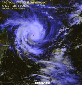
Satellite image TC Enawo
Tropical Cyclone Enawo was centered over the South Indian Ocean about 402NM north of Port Louis, Mauritius and was moving WSW slowly. SST are warm (29-30C)so intensification is likely as it begins to move toward Madagascar. Max winds are likely to peak near 110 knots during the next 36 hour then weaken somewhat as it nears the coast of Madagascar by 1200UTC March 7th.

JTWC Track Forecast for TC Enawo
Post Views:
161
About Fred Pickhardt
I am a marine meteorologist and sailed briefly with American Export Lines in the Far East trade after graduating from State University of New York Maritime College. I have extensive experience in weather analysis, weather forecasting, optimum ship routing, vessel performance evaluations and forensic weather event reconstructions. I founded Ocean Weather Services and as Owner and Chief Consultant currently provide optimum ship routing services and forensic marine weather reports to the maritime industry.
