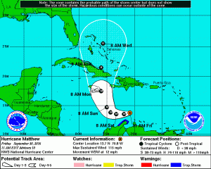
 Hurricane Matthew continues to intensify and currently has max winds of 100 knots. Matthew is moving towards the WSW at about 10 knots with hurricane force winds extending outward 20-30 NM and 50 knot or higher winds outward 25-30 NM to the south and 80 NM to the north.
Matthew is forecast to continue WSW to W for another 24 hours then turn NW to NNW during Sunday and Monday bringing the center close to or over eastern Jamaica Monday morning then across eastern Cuba Monday night and early Tuesday with max winds of 100 knots, possible higher.
After passing across eastern Cuba most models take Mathew northward across the Bahamas to off Cape Hatteras, however, there is some risk that it could move closer the east coast of Florida.


