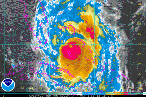
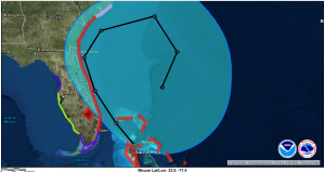
Hurricane Mathew at 11am EDT 1500 UTC is once again gaining strength with max winds now at 120 knots (about 140 mph). Environmental conditions appear favorable for additional intensification today while Matthew approaches the east coast of Florida.
Currently hurricane force winds extend outward abut 30-50 NM to the west and 40-50N to the east. Damaging 50 knot (58mph) winds extend outward 70 NM except only 40 NM to the southwest. Tropical storm force (gale) winds extend outward 70-100 NM west and 130-140 NM east.
After 24 hours, land interaction is likely to cause some weakening, and later in the period increasing shear should cause a more rapid decrease in winds. Matthew is moving toward the northwest or 325 degrees at 10 kt. A turn towards the north-northwest and later northeast is still anticipated.
Matthew is likely to produce devastating impacts from storm surge, extreme winds, and heavy rains in the northwestern Bahamas today, and along extensive portions of the east coast of Florida tonight. By tonight max winds are forecast to be about 125 knts (145mph).
When a hurricane is forecast to take a track roughly parallel to a coastline, as Matthew is forecast to do from Florida through South Carolina, it becomes very difficult to specify impacts at any one location. Only a small deviation of the track to the left of the NHC forecast could bring the core of a major hurricane onshore within the hurricane warning area in Florida and Georgia. Modest deviations to the right could keep much of the hurricane-force winds offshore.


