Tuesday 11pm EDT Hurricane Irma Update
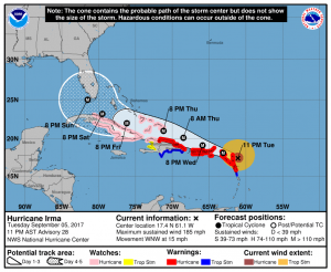
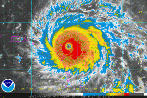
Major Hurricane Irma located near 17.4N/61.1W was moving towards the west-northwest at 13 knots (15 mph) with a min pressure of 916 MB and max winds to 160 knots (185 mph) and possible gusts to 195 knots (225 mph).
The radius of hurricane force winds are currently 45NM to the northeast and 30 NM to the southwest. Storm force 50 knot or higher winds extend out 80 NM to the northeast and 40 NM to the southwest. Gale force (34 knot) winds extend out 150 NM to the north and 90 NM to the southwest.
On the forecast track, the extremely dangerous core of Irma will move over portions of the northern Leeward Islands tonight and early Wednesday, move near or over portions of the northern Virgin Islands Wednesday, and pass near or just north of Puerto Rico late Wednesday and Wednesday night. As Irma starts to interact with the larger islands of Puerto Rico, Hispaniola and later Cuba, max winds could start to slowly diminish, however, Irma will still likely remain a major hurricane over the next few days.
 Comments: As Irma approaches Cuba, the mountains will tend to reduce the wind flow on the south side of the storm causing it to turn more into Cuba which in turn will tend to weaken it more. Once it moves away from the Cuban coast the upper winds will try to pull it northward towards Florida. If this occurs then the highest risk are the Keys and the southwest portion of Florida then as it interacts with Florida the eye will tend to track somewhat more towards the north-northeast taking it across Florida.
A fair number of models, however, turn Irma northward sooner either coming up the Florida East Coast or even offshore. Keep in mind that 5 days out the average position error is about 225 miles. Either way hurricane force winds will likely occur over some or much of South Florida as well as parts of Central and Northeastern Florida while at least tropical Storm Force winds are likely over most of the Florida peninsula. Given the large track errors with models I would say to continue to prepare for the worse and we can all pray for the best. 
Timing for Florida looks like most of the impact will be from late Saturday through Sunday into Monday.


