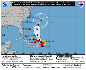
Hurricane Maria at 1100 AM AST (1500 UTC) Thu Sep 21 2017
Maria has a large 40 nm wide eye and max winds of about 100 knots (115mph). Hurricane force winds extent outward 40-50 NM while 50 knot (58mph) or higher winds extend out 60-80 NM and gales outward 110-130 NM.
Maria is moving over the remnant cold wake leftover from Hurricane Irma, but it should begin to move over warmer SST soon so some strengthening is still forecast. After about 48 hours, increasing wind shear will start to gradually weaken the system. Max wave heights estimated to be 48 feet (14.6 meters).
Currently Maria is moving towards the northwest (310 degrees) at 8 kt (9mph), however, Maria is expected to turn gradually northward in 3-5 days. Current thinking keeps Maria well off the US East Coast,however, there is still uncertainty in the final track so folks from the Carolinas to southern New England need to follow the updates on Maria.
Catastrophic flooding is occurring on the island, especially in areas of mountainous terrain. A Hurricane Warning is in effect for the northern coast of the Dominican Republic, the Turks and Caicos Islands, and the southeastern Bahamas, where Maria is expected to bring dangerous wind, storm surge, and heavy rainfall.


