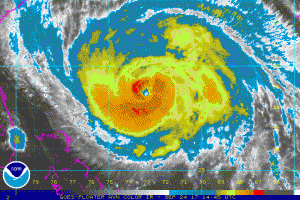
The National Hurricane Center (NHC) has reduced the max winds of Maria to 90 knots (105 mph) which is a Cat 2 storm, based on the latest information from the NOAA and Air Force Hurricane Hunter aircraft. The minimum pressure in Maria, however, was 947 mb which suggests that Maria still has the potential for stronger Cat 3 winds, especially while it remains over very warm sea surface temperatures (SST).
Hurricane force winds currently extend outward 50 NM to the northeast and 35 NM to the southwest. Damaging 50 knot (58 mph) or higher winds extend outward 100 NM to the northeast and 60 NM to the southwest. Maximum significant wave height is estimated at 42 feet (12.8 meters).
Current movement is north-northwest at about 8 knots (9 mph) and this track should continue for another 48-72 hours. After 72 hours, Maria should turn sharply towards the east-northeast.
The SST temperatures also suggest that Maria may still track somewhat farther to the west than the official NHC track, but the turn towards the east-northeast is very likely, due to increasing upper winds from the west and prevailing colder SST off the Middle Atlantic Coast.
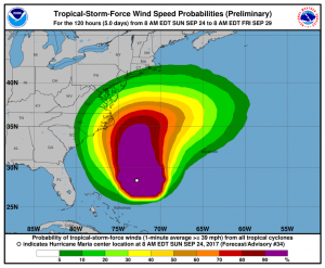
Since Maria is a large hurricane, the associated tropical-storm-force winds could reach a portion of the North Carolina coast by mid-week regardless of the exact track.


