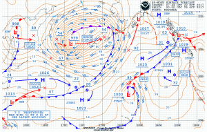
NOAA OPC Surface Analysis
Post-Tropical Hurricane Force Storm Lan will move rapidly northeast and transfer its energy to a developing storm low that will move towards the southwestern Bering Sea and western Aleutian islands.
This developing storm will deepen very rapidly to a dangerous 938 MB hurricane force storm creating winds of 55 to 75 knots and seas building 36-56 feet (11-17 meters) within 360 NM SE and 420 NM SW of the center within 24-36 hours. This system will create a dangerous situation for ship traffic steaming along northern routes.
Learn more about the winter hurricanes

NOAA OPC Wave Height Forecast

NOAA OPC Forecast 0000UTC 25 October 2017
Post Views:
607
About Fred Pickhardt
I am a marine meteorologist and sailed briefly with American Export Lines in the Far East trade after graduating from State University of New York Maritime College. I have extensive experience in weather analysis, weather forecasting, optimum ship routing, vessel performance evaluations and forensic weather event reconstructions. I founded Ocean Weather Services and as Owner and Chief Consultant currently provide optimum ship routing services and forensic marine weather reports to the maritime industry.


