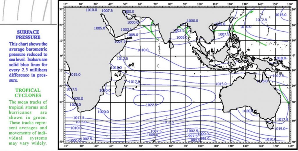
South Indian Ocean
A ridge of high pressure normally extends from South Africa eastward to the west coast of Australia, mainly between 25-30 south latitudes. Southward of about 35 south latitude, westerly winds prevail averaging forces 5-6 (17-27 knots) with significant wave heights generally 2-3 meters. Northward of the prevailing ridge, winds tend to be from the southeast averaging force 4-5 (11-21 knots) with waves mostly 1.5-2 meters, becoming southeast to south forces 3-4 (7-16 knots), waves 0.5-1 meter nearing the equator.
The risk for encountering gale force (BF8/34kt) or higher winds is 10% or less from the equator to about 35 S latitude then increases from 10% to 26% southward of 35 S. The risk of encountering waves of 12 feet (3.7 meters) or higher is 30-40% from about 40S southward, diminishing to 20-30% near 30 S and generally 15% or less north of 20 S latitude.
North Indian Ocean
Arabian Sea
The Southwest Monsoon establishes itself in June and the frequency of gales increases rapidly over the western half of the Arabian Sea reaching over 10% with the highest risk near 14 N 57 E.
The risk of encountering waves of 12 feet (3.7 meters) or more increases over this area from less than 10% in May to as high as 40% or more in June. In the same area there is also a 5% risk of encountering waves of at least 20 feet (about 6 meters).
Bay of Bengal
Generally a southwest monsoon prevails in June, averaging forces 4-5 (11-21 knots) with waves mostly 1.5-2 meters.
Tropical Cyclones
Cooler temperatures in the southern hemisphere in June reduce the risk for tropical cyclone development to less than 1 every decade. Over the North Indian Ocean there is a 70% risk for tropical cyclone development and mostly confined to the eastern Arabian Sea and Bay of Bengal.


