
 Significant flash flooding during the early morning of Tuesday, July 26th, 2022, occurred along the I-70 corridor in Missouri and I-64 corridor in Illinois. Multiple thunderstorms with rainfall rates exceeding 2in/hr. affected this area, including the St. Louis metropolitan area with up to 12 inches of rain falling from northern Montgomery County in Missouri to St. Clair County in Illinois. The storm caused multiple swift water rescues and scores of flooded interstates and homes across the St. Louis metropolitan area. One fatality was reported in St. Louis City, where a man drowned in his car.
These thunderstorms caused a narrow, but intense swath of heavy rainfall: most of the area saw at least a few inches of rainfall with a narrow band of 6 to 12 inches stretching from east central Missouri to southwest Illinois.

Multi-Radar Multi-Sensor (MRMS) 24hr Radar-Estimated Rainfall as of 12pm on July 26th.
In addition, deadly and destructive flooding is also occurring in Kentucky and other parts of Appalachia July 28th-30th as several inches of rain have fallen over the area in a short period of time and is a life-threatening situation similar to the disaster in St. Louis earlier this week. Floodwaters have claimed at least 25 lives in Kentucky and have washed away homes, roads, and bridges. Kentucky’s governor expanded a state of emergency declaration and said the death toll was likely to increase.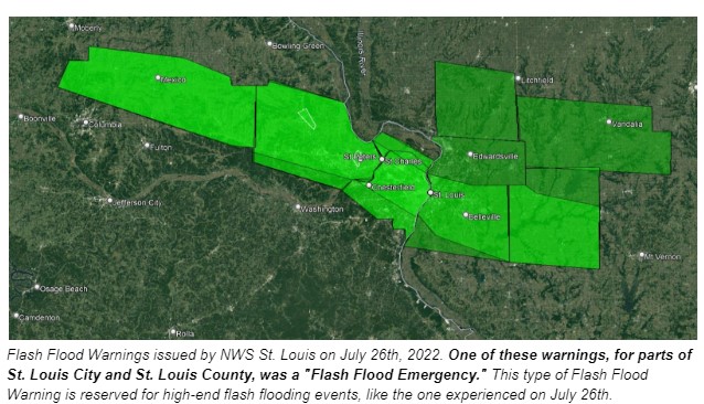
What is the cause?
The heavy rain fell north of a stationary front (a boundary between warm humid air and cooler air to the north) across southern Missouri and Illinois, and eastward into Kentucky. Strong low-level winds (around 5,000 feet) brought in high amounts of low-level moisture which interacted with the front and with an upper-level jet stream to the north and produced a mesoscale convective system (complex of thunderstorms moving across the same area for more than 6 hours). This type of weather pattern is not unusual as there have been many similar warm-season heavy rainfall events in the central US in the past that were produced by mesoscale convective systems (MCSs) that developed above and north of a surface front in the past.

A conceptual model for the meteorological setup of the flash flooding event that occurred on July 26th, 2022 in the St. Louis metropolitan area. Image Credit NOAA NWS St. Louis
A paper written by Moore et al. (2003) found that the heavy-rain region of elevated MCSs is located, on average, about 160 km (100 miles) north of a semi stationary frontal zone, in a region of low-level moisture convergence that is elongated westward on the cool side of the frontal boundary.
In an earlier paper published by NOAA in 1994, stated that “flash flooding often results from intense, long-duration rainfall associated with MCSs. During the summer of 1993, the continuous development and movement of MCSs over portions of the Missouri and upper Mississippi River basins for several months contributed to numerous individual flash-flood events and prolonged large-scale river flooding, resulting in 48 fatalities and economic losses estimated at $20 billion”.
A conceptual model for the meteorological setup of the flash flooding event that occurred on July 26th, 2022 in the St. Louis metropolitan area. Image Credit NOAA NWS St. Louis
References
July 26th, 2022 Historic Flash Flooding in the St. Louis Metro Area, NOAA NWS Office, St. Louis Mo.
Moore et al. (2003) in the AMS Weather and Forecasting journal, The Environment of Warm-Season Elevated Thunderstorms Associated with Heavy Rainfall over the Central United States
NOAA, 1994: The Great Flood of 1993. Natural Disaster Survey, NOAA, Rockville, MD
Junker, N. W., R. S. Schneider, and R. A. Scofield, 1995: The meteorological conditions associated with the great Midwest flood of 1993. 14th Conf. on Weather Analysis and Forecasting, Dallas, TX, Amer. Meteor. Soc.,