North Atlantic Marine Weather Outlook

North Atlantic Jet Stream

NOAA OPC 500 mb Forecast Chart

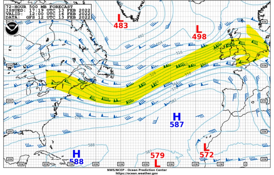
A strong jet stream will prevail across the North Atlantic this week from off the US East Coast east then northeastward across the UK into Northern Europe. 


 Frequent gale to storm to occasionally hurricane-force winds and seas  are expected near and south of low pressure systems. As a result, westbound shipping will likely encounter delays.

North Atlantic Stormtracks

NOAA OPC North Atlantic 48 hour Forecast Chart


Intense storm lows will likely move from the central North Atlantic east-northeastward then eastward across the UK and North Sea into northern Europe on/about February 16th and again on the 18th. 


Posted in North Atlantic, Ocean Storms, Weather Routing | Tagged , , , , | Leave a comment

Massive North Pacific Hurricane-Force Storm

Japanese Himarari – 8 Visual Satellite image

As posted 3 days ago, a large intense storm low is rapidly deepening over the west-central North Pacific and is moving northeastward at 15 knots across the main shipping lanes.  Max surface winds currently are approaching 65 knots  with additional strengthening expected over the next 12-18 hours when max significant wave heights are forecast to reach up to 15 meters (about 50 feet).

NOAA OPC 1800 UTC Satellite Image

Posted in North Pacific, Ocean Storms | Tagged , , , | Leave a comment

North Atlantic Marine Weather Outlook

NOAA OPC 500 mb Forecast Chart

A strong upper-level trough is forecast to move off the US East Coast early this week which will enhance the development of a frontal low pressure frontal wave Sunday.

NOAA OPC 48 Hour Surface Forecast Chart


Conditions over the western North Atlantic will favor rapid deepening of this low into a hurricane-force storm as it passes east of Newfoundland on Tuesday (15th) with winds increasing up to 75 knots possible. 

Heavy freezing spray conditions will be likely over the Gulf of St. Lawrence, as well as the waters near Nova Scotia as far south as 44 N and Newfoundland to 46 N.

NOAA OPC 96 Hour Surface Forecast


Posted in Meteorology, North Atlantic, Ocean Storms, Ocean Weather, Weather Routing | Tagged , , , , | Leave a comment

Tropical Cyclone Dovi Rapidly Intensifies

Satellite image Tropical Cyclone Dovi

Tropical Cyclone Dovi has intensified rapidly and currently packs max winds of 75 knots about 70 nm southeast of Noumea, New Caledonia and is moving southwest at 12 knots.  Max significant wave heights estimated at 24 feet (7.3 meters),  Dovi should continue to intensify as it moves over warm sea surface temperatures with low vertical shear peaking around 90-100 knots over the next 12 hours. 


Thereafter, increasing wind shear will weaken Dovi with a transition into an extratropical low beginning after about 24 hours with a more southerly and eventually southeasterly track likely.

Tropical Cyclone Dovi Forecast Track via JTWC

Posted in Ocean Storms, South Pacific, Tropical Cyclones | Tagged , , | Leave a comment

Hurricane-Force Storm Forecast over West Pacific

NOAA OPC 48 hour Surface Forecast

A developing complex gale low system south-southeast of Japan is forecast to deepen to a storm-force low over the western North Pacific east of Japan during the next 36-48 hours.


Thereafter, this system will  deepen rapidly into a hurricane-force 949 mb storm over the west-central North Pacific by the 13th with significant wave heights building to 14 meters (46 feet) as it moves across some of the main shipping lanes in the North Pacific.

NOAA OPC 96 hour Surface Forecast


NOAA OPC 96 hour Significant Wave Forecast

Posted in North Pacific, Ocean Storms, Weather Routing | Tagged , , , | Leave a comment

Tropical Cyclone Dovi forms ENE of New Caledonia

Tropical Cyclone Dovi
image via JTWC

The tropical disturbance over the South Pacific yesterday has now been named Tropical Cyclone Dovi and is now located east-northeast of New Caledonia and is moving southeast at 5 knots with max winds of about 40 knots.


Dovi is forecast to move south-southeastward then southward after about 36 hours but should intensity to about 65 knots within 48 hours. Thereafter cooler sea surface temperatures will tend to weaken the system as it begins to transition into a subtropical cyclone.  On the forecast track, Dovi should pass east of New Caledonia about 1200 UTC on the 10th. 

Tropical Cyclone Dovi Forecast Track via JTWC

Posted in Ocean Storms, South Pacific, Tropical Cyclones | Tagged , , | Leave a comment

South Indian Ocean Marine Weather Outlook

A ridge of high pressure prevails across the South Indian Ocean, mostly between 32S and 42S latitudes.  Far to the south, an intense 948mb low near 57S/19E is moving eastward and weakening. Post-Tropical Cyclone Batsirai is now well south of Madagascar (near 36S/43E) and is accelerating southeastward.

Indian Ocean Surface chart via windy.com

North of the ridge winds/seas mainly easterly forces 3-5 while south of the ridge westerlies prevail forces 5-7.  A tropical cyclone may be forming near 17S/105E.

Tropical Cyclone Formation – Image via JTWC


Posted in Ocean Weather, Weather Routing | Tagged , , | Leave a comment

North Pacific Marine Weather Outlook

The primary jet stream continues to be displaced south of 40 N latitude over the western and central North Pacific then turns northeastward towards the Gulf of Alaska due to a persistent blocking ridge over the easternmost North Pacific. 

NOAA OPC 500mb Forecast Track


As a result the primary storm tracks will be from south of Japan to near 42N/180 then northeast over the Gulf of Alaska. Frequent gale to storm westerlies likely south of low pressure centers with brief intervals of hurricane-force conditions possible, especially in the central North Pacific.

NOAA OPC Surface Forecast

Posted in North Pacific, Ocean Storms, Ocean Weather, Weather Routing | Tagged , , , , | Leave a comment

Intense Hurricane-Force Storm over North Atlantic

A rapidly deepening storm over the western North Atlantic, northeast of Newfoundland, will deepen to a 928 mb hurricane-force storm by 1200 UTC 7th off the southeast coast of Greenland with winds up to 90 knots possible between the Greenland coast and the low center.

  Significant wave heights could build up to 18 meters (59 feet).

By comparison, he Braer storm of January 1993 was the deepest ever recorded cyclone outside of the Tropics with a minimum core pressure of 914 mb.

NOAA OPC Significant Wave Height Forecast

How unusual is this?

Each winter season has, on average, about 37 non-tropical hurricane force wind events occur over the North Pacific and about 45 events over the North Atlantic. NOAA Ocean Prediction Center  issues a “Hurricane Force Wind Warning”  when sustained winds, or frequent gusts, of 64 knots (74 mph) or greater, either predicted or occurring, and not directly associated with a tropical cyclone.”

Read more here


Posted in NOAA OPC, Ocean Storms, Weather Routing | Tagged , , , | Leave a comment

Intense Tropical Cyclone Batsirai headed for Madagascar

Tropical Cyclone Batsirai Satellite Image via JTWC

Tropical Cyclone Batsirai over the South Indian Ocean is moving west  at 4 knots with max winds estimated to 115 knots and significant wave heights to 16 meters (52 feet). Batsirai is an intense, highly symmetrical tropical cyclone with a 30 nm wide eye.

Batsirai is moving through a favorable environment with warm SST and low wind shear and is forecast to peak at about 120 knots prior to landfall along the east coast of Madagascar about 1500 UTV/5th.

Tropical Cyclone Batsirai Forecast Track via JTWC


Batsirai will weaken rapidly as it crosses Madagascar, exiting over the Mozambique Channel as a tropical storm but only a modest re-intensification is expected as it turns southward over colder water. 

Posted in Ocean Storms, Tropical Cyclones | Tagged , , , | Leave a comment