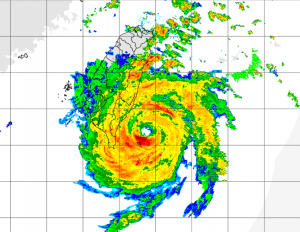
RADAR depiction from Taiwan
Super Typhoon Nepartak at 1200 UTC was located about 196 NM SSE of Taipei, Taiwan and was moving WNW at 8 knots. Maximum winds were estimated to be 140 knots. Typhoon force winds extend outward 45 NM to the southwest and 60 NM to the northeast while 50 knot or higher winds extended outward 70 NM southwest and 90 NM to the northeast. Max significant wave height estimated to be 42 feet (almost 13 meters). Nepartak is expected to make landfall over southern Taiwan between 2100 UTC on the 7th and 0000 UTC on the 8th.
Radar Link from Taiwan

JTWC Forecast Traxk
Post Views:
713
About Fred Pickhardt
I am a marine meteorologist and sailed briefly with American Export Lines in the Far East trade after graduating from State University of New York Maritime College. I have extensive experience in weather analysis, weather forecasting, optimum ship routing, vessel performance evaluations and forensic weather event reconstructions. I founded Ocean Weather Services and as Owner and Chief Consultant currently provide optimum ship routing services and forensic marine weather reports to the maritime industry.


