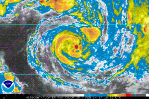
Meteosat Satellite Photo TC Dineo
Tropical Cyclone Dineo at 1500UTC 14 Feb was centered about 78 NM west of Europa Island in the Mozambique Channel and was moving soutwestward slowly with max winds of about 55 knots. Conditions are favorable for development and Dineo is forecast to reach hurricane strength shortly and turn more towards the west making landfall over southern Mozambique around 1800UTC on the 15th with max winds of 70-80 knots.

JTWC Forecast Track
Post Views:
825
About Fred Pickhardt
I am a marine meteorologist and sailed briefly with American Export Lines in the Far East trade after graduating from State University of New York Maritime College. I have extensive experience in weather analysis, weather forecasting, optimum ship routing, vessel performance evaluations and forensic weather event reconstructions. I founded Ocean Weather Services and as Owner and Chief Consultant currently provide optimum ship routing services and forensic marine weather reports to the maritime industry.

