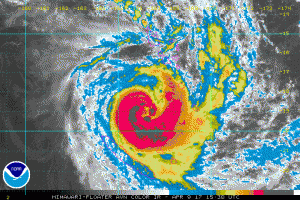
TC Cook IR satellite image
TC Cook, as of 1500 UTC 09 April was centered about 225 NM north of Noumea, New Caledonia in the South Pacific and was moving towards the southwest at about 7 knots. Currently max winds are estimated at 70 knots and the forecasts suggest max winds could reach 90-100 prior to making landfall on the island of New Caledonia near 1200 UTC April 10th.
Latest track forecast
Post Views:
614
About Fred Pickhardt
I am a marine meteorologist and sailed briefly with American Export Lines in the Far East trade after graduating from State University of New York Maritime College. I have extensive experience in weather analysis, weather forecasting, optimum ship routing, vessel performance evaluations and forensic weather event reconstructions. I founded Ocean Weather Services and as Owner and Chief Consultant currently provide optimum ship routing services and forensic marine weather reports to the maritime industry.

