

Hurricane Milton 2024
As of April, conditions in the North Atlantic appear to favor a somewhat more active season than normal, however, less active than in 2024. Several hurricane outlooks have already been published, predicting between 10 and 18 named storms with 5-10 becoming hurricanes and 2-6 becoming major hurricanes. The normal season will produce 14 named storms, 7 hurricanes, and 3 major hurricanes.
One factor is that La Nina (which favors storm development) has ended, and the tropical East Pacific conditions are forecast to be neutral during the peak of the 2025 season.
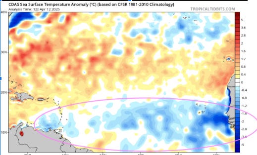
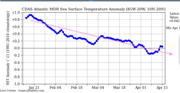
In addition, Sea Surface Temperatures (SST) remain warmer than normal over the western portions of the Atlantic and Caribbean, however, a significant cooling trend has developed since January over the eastern portion of the Main Development Region (MDR) and has slowly spread westward. Early in the seasons tropical storms tend to develop over the western Caribbean and southwestern Atlantic, however, the MDR is the primary location for hurricanes that threaten the U.S. and Caribbean during the peak of hurricane season.
.
Early Hurricane Outlooks
FORECAST Named Storms Hurricanes Major Hurricanes
Colorado State University 17 9 4
AccuWeather 13-18 7-10 3-6
WeatherBell 10-14 5-7 2-3
Fox Weather Analogs 14.8 8.6 3.2
TSR 15 7 3
Mean 15 8 3
2024 Season 18 11 5
Normal 14 7 3
Tracks and Impacts
The North American Multi-Model Ensemble (NMME) is a seasonal forecasting system that consists of multiple coupled models from North American modeling centers.
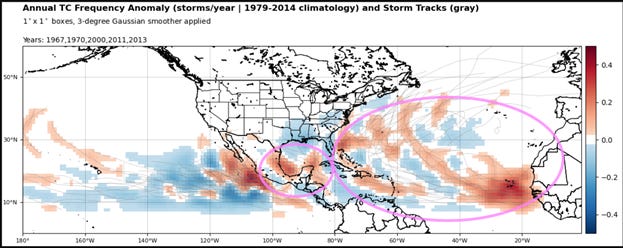
Based on the closest SST anomaly analog years (2013, 1970, 1967, 2000, and 2011), the 2025 hurricane season may see many storm tracks remaining over the Atlantic. Highest probability of impacts may be in the northern and eastern Caribbean to the Bahamas as well as the northwestern Caribbean and southern Gulf.
Fred Pickhardt,
Ocean Weather Services