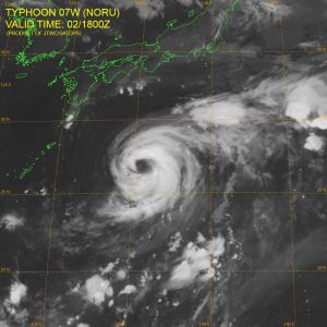
Typhoon Noru Satillite image
Typhoon Noru, over the western North Pacific, is moving towards the N-NW at about 5 knots with max winds estimated at 95 knots. . The large center is in an area of low vertical wind shear and very warm sea temperatures. Noru is forecast to move northwest for another 24 hours then start turning more towards the north. Max winds will likely reach 105 knots or more as it starts the turn northward before gradually weakening.
Latest Track Forecast

JTWC Forecast Track
Post Views:
500
About Fred Pickhardt
I am a marine meteorologist and sailed briefly with American Export Lines in the Far East trade after graduating from State University of New York Maritime College. I have extensive experience in weather analysis, weather forecasting, optimum ship routing, vessel performance evaluations and forensic weather event reconstructions. I founded Ocean Weather Services and as Owner and Chief Consultant currently provide optimum ship routing services and forensic marine weather reports to the maritime industry.


