Possible Tropical Storm Development eastern Gulf early next week


NOAA Satellite photo

NOAA Satellite photo

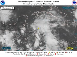
A large area of showers and thunderstorms over the western Caribbean Sea has been moving W-NW.  An area of low pressure is forecast to develop near or over the Yucatan Channel and there is a 60% risk that a tropical cyclone will form over the weekend then move north or northeastward into the eastern Gulf of Mexico towards Florida early next week. Locally heavy rains and some flooding are possible over portions of the Yucatan Peninsula, western Cuba and the Florida Peninsula during the next several days.  There is also a possibility this system may reach tropical storm intensity prior to reaching the west coast of Florida.

About Fred Pickhardt

I am a marine meteorologist and sailed briefly with American Export Lines in the Far East trade after graduating from State University of New York Maritime College. I have extensive experience in weather analysis, weather forecasting, optimum ship routing, vessel performance evaluations and forensic weather event reconstructions. I founded Ocean Weather Services and as Owner and Chief Consultant currently provide optimum ship routing services and forensic marine weather reports to the maritime industry.
This entry was posted in Ocean Storms, Tropical Cyclones and tagged , , , . Bookmark the permalink.

Leave a Reply

Your email address will not be published. Required fields are marked *