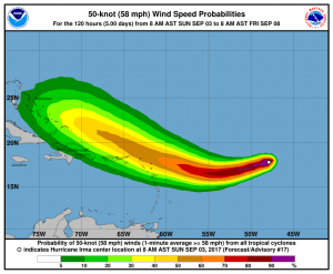
Hurricane Irma is tracking towards the west-southwest with max winds of about 100 knots. The first recon flight will enter Irma late this afternoon so a better picture on intensity will be available this evening.
Strong high pressure to the north is pushing Irma west-southwest but a return to a west then west-northwest track is likely in about 2-3 days. Irma is forecast to move into an area of more favorable conditions which should allow for gradual strengthening during the next 2 to 3 days with max winds increasing to around 120 knots.
Over the next few days the highest risk for 50 knot or higher winds will be for the Islands of St. Martin, Barbuda, Antigua, St. Thomas and St Kits Tuesday into Wednesday (See graphic). In the longer term the treat will be for Puerto Rico and Haiti (Wednesday-Thursday), then the Bahamas Friday to Sunday and eventually the US East Coast, south of Cape Hatteras (next Saturday to Tuesday).
Keep in mind there is a high uncertainty in tracks beyond 4-5 days and subject to major changes. In any case this will be a real issue for shipping between the USEC and Puerto Rico and later between Europe and the USEC.


