Update: Tropical Cyclone Maha over Arabian Sea

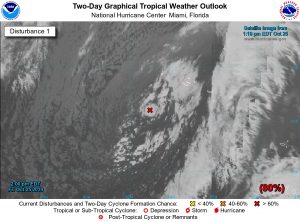
Tropical Cyclone Maha Satillite image

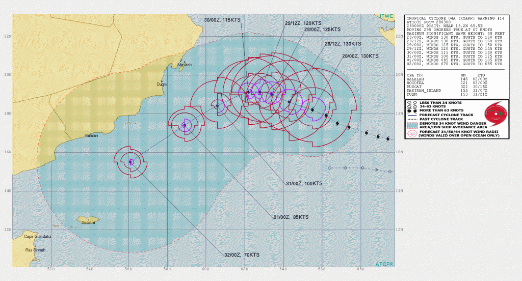
TC Maha, located about 469 NM south of Karachi has been moving NW at 8 knots with max winds now at 60 knots with a maximum significant wave height of about 19 feet.  Maha is forecast to intensify to over 100 knots within 36 hours then after about 48 hours, Maha is likely to turn back towards the east.

JTWC Track Forecast for TC Maha

Posted in Ocean Storms, Tropical Cyclones | Tagged , | Leave a comment

Subtropical Storm Rebekah forms within larger North Atlantic Gale

IR Satellite image Subtropical Storm Rebekah

Update: The disturbance within the larger North Atlantic gale low has been designated as a subtropical cyclone by the NHC with an initial intensity of 40 knots. Like Pablo just a few days ago, Rebekah is currently rotating around a larger non-tropical low pressure system

NOAA NHC Forecast track

At 500 PM AST (2100 UTC), the center of Subtropical Storm Rebekah was located near latitude 38.3 North, longitude 40.7 West. Rebekah is moving toward the east near 11 knots/13 mph/20 km/h and is forecast to turn toward the east-northeast tonight. A turn back toward the east and east-southeast is anticipated on Thursday.

NOAA OPC 1800 Z Surface Analysis

Posted in Ocean Storms, Tropical Cyclones | Tagged , , | Leave a comment

Possible Subtropical Storm forming within larger North Atlantic Gale

NOAA NHC Graphical Tropical Outlook

Showers associated with a low pressure system located several hundred miles
west of the westernmost Azores continue to show signs of organization. If the current organization of shower activity persists, advisories will likely be initiated on a tropical or subtropical storm later today or tonight. The system will likely move over colder waters on Thursday and further development is unlikely after that time. The low is producing gale-force winds and
these winds are forecast to continue today, regardless of development. For more information on this system, see High Seas
Forecasts issued by the National Weather Service. Source: NOAA NHC

NOAA OPC Surface Analysis


Posted in Ocean Storms, Tropical Cyclones | Tagged , , | Leave a comment

New Tropical Cyclone forms off SW Coast of India

Satellite image TC 05A

A new Tropical Cyclone (05A) has formed off the southwest coast of India and was moving NW at 14 knots with max winds of about 45 knots. This system is moving over warm ocean water so continued strengthening is expected, reaching hurricane strength in about 48 hours.

Over the next 72 hours the TC should continue moving towards the northwest, thereafter turning more westward while continuing to strengthen over the Arabian Sea.. 

JTWC track forecast

Posted in Ocean Storms, Tropical Cyclones | Tagged , , | Leave a comment

Tropical Cyclone Kyarr now 130 knots over Arabian Sea

TC Kyarr

EUMETSAT image TC Kyarr

Tropical Cyclone Kyarr, over the Arabian Sea about 402 NM ESE of Masirah Island has been moving WNW at 7 knots with max winds of 130 knots. Ocean temperatures remain warm at 28-29 C so Kyarr will remain over warm water for the short-term, however, after about 24 hours conditions will become less favorable and gradual weakening is expected.  After 48 hours a turn towards the southwest is also forecast but should remain at hurricane strength for several more days.   Estimated maximum significant wave height is 48 feet (14.6 meters).

TC Kyarr forecast

JTWC forecast track for TC Kyarr

Posted in Ocean Storms, Tropical Cyclones | Tagged , , | Leave a comment

North Atlantic Hurricane Force Wind Warning

North Atlantic Hurricane Force Wind Warning

NOAA OPC North Atlantic Surface Analysis 12Z 27 October 2019

A deepening 976 mb  low over the west-central North Atlantic is moving NE at 10 knots with winds of 50-70 knots and seas to 29 feet (about 9 meters)  within 180 NM west of the center. Seas are forecast to build up to 35 feet (10.7 meters) over the next 12 to 24 hours.

NOAA OPC North Atlantic Surface Analysis

Posted in Ocean Storms | Tagged , , , | Leave a comment

Pablo now a hurricane over the eastern North Atlantic

NOAA IR Satellite image Hurricane Pablo

Pablo is now a hurricane over the eastern North Atlantic with max winds of 65 knots even though it is moving over relatively cool ocean waters.  Pablo is moving N-NE at 28 knots over even colder ocean water so it should weaken and then merge with a nearby frontal system becoming extratropical over the next 12-24 hours and eventually being absorbed into the larger low pressure system to the west over the next 48-72 hours.

NOAA OPC Eastern North Atlantic Surface Analysis

NOAA NHC Hurricane Pablo track forecast

Posted in Ocean Storms, Tropical Cyclones | Tagged , , | Leave a comment

Tropical Storm Pablo forms southwest of Azores

Satellite Image

NOAA Satellite Image North Atlantic

A new tropical cyclone has formed within a larger extratropical cyclone in the northeastern Atlantic. Pablo is a very small-scale tropical cyclone, but satellite data clearly show a well-defined but small circulation with 40-kt winds embedded within the larger low.

Pablo is currently moving toward the east-southeast at about 9 kt while embedded within the circulation of the larger extratropical low. Pablo should then turn toward the northeast and increase its forward speed with some strengthening possible over the next 36 hours.

NOAA NHC Forecast Track


Note the larger scale low is currently causing winds of 30 to 45 knots and seas to 9 meters (about 30 feet).

NOAA OPC Wave Height Analysis

Posted in NOAA OPC, Ocean Storms, Tropical Cyclones | Tagged , , , , | Leave a comment

Typhoon Bualoi update

Typhoon Bualoi, SSE of Iwo To is moving NW at 14 knots with max winds of 125 knots and gust to 150 knots. Maximum significant wave heights currently to 44 feet (about 13.5 meters). This is a small storm with hurricane force winds extending outward only 20-25 NM from the center.

Typhoon Bualoi Satellite image

Over the next 24-48 hours Bualoi will gradually turn northward then NNE. Conditions favor additional strengthening over the next 24-36 hours then gradually weakening is forecast.

JTWC Forecast Track Typhoon Bualoi

Posted in Ocean Storms, Tropical Cyclones | Tagged , | Leave a comment

HURRICANE FORCE WIND WARNING WEST PACIFIC

A developing gale low east of Japan will move ENE with winds developing 50-65 knots within 240 NM south of the center and seas building to 36 feet (about 11 meters)  within the next 48 hours then turning northeastward.

NOAA OPC Surface Analysis

NOAA 48 Hour Surface Forecast

NOAA OPC 48 hour Significant Wave Height Forecast

Posted in Ocean Storms | Tagged , , , | Leave a comment