Hermine Sunday Update

NOAA NHC Track Forecast

NOAA NHC Track Forecast

Hermine remains a deep cyclone off the US East Coast and an Air Force reconnaissance aircraft measured peak surface winds near 60 kt.  The circulation is over warm water so Hermine could regain some tropical characteristics during the next 2-3 days.

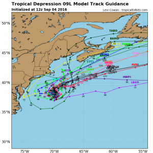
Currently the center continues to move towards the northeast away from the Middle Atlantic coast, however, a turn towards the north or NNW is expected during the next 36-48 hours before returning to a NE or ENE track. Forecasts suggest Hermine will reach hurricane strength by late Monday but will weaken again by the 7th.   Currently significant wave heights are up to 27 feet (8.2 meters) to the northwest of the center.

Model Storm tracks via tropicaltidbits.com

Model Storm tracks via tropicaltidbits.com


The risk for encountering gale force winds are currently estimated to be:

Philadelphia – 25%
Atlantic City – 35%
New York City – 36%
Montauk Point – 62%
Boston – 48%

ASCAT Satellite Surface Winds

ASCAT Satellite Surface Winds

NOAA OPC Wave chart

NOAA OPC Wave chart

About Fred Pickhardt

I am a marine meteorologist and sailed briefly with American Export Lines in the Far East trade after graduating from State University of New York Maritime College. I have extensive experience in weather analysis, weather forecasting, optimum ship routing, vessel performance evaluations and forensic weather event reconstructions. I founded Ocean Weather Services and as Owner and Chief Consultant currently provide optimum ship routing services and forensic marine weather reports to the maritime industry.
This entry was posted in Ocean Storms, Tropical Cyclones and tagged , , , , , , . Bookmark the permalink.

Leave a Reply

Your email address will not be published. Required fields are marked *