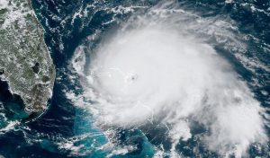
Visible satellite image Hurricane Dorian Sept. 1, 2019 making landfall on Elbow Cay in The Bahamas. Image credit: NOAA/RAMMB
Will 2022 bring yet another very active hurricane season or will it be more in-line with the long-term average of 12-13 named storms, 6-7 hurricanes and 2-3 major hurricanes?
The Sea Surface Temperatures (SST) over the Atlantic Main Development Region (MDR) have been cooling since mid February, especially in the eastern half of the region. More than half of all hurricanes and nearly 80% of major hurricanes develop in the MDR, so if this cooling trend continues, fewer major hurricanes will develop this season. Development of tropical cyclones requires heat energy from the ocean surface and generally requires SSTs of at least 26.5 C (80 F).
In recent years we have seen a cool pattern of SST anomalies develop during the winter months over the MDR. particularly over the eastern half, only to have temperatures return to warmer than normal during the late summer and autumn months. The question is will this pattern repeat itself this year or not? 
An important factor driving an active versus inactive Atlantic hurricane seasons is the strength of the Atlantic multi-decadal oscillation (AMO).
The AMO is a series of long-duration changes in the sea surface temperature of the North Atlantic Ocean, with cool and warm phases that may last for 20-40 years at a time. These changes are natural and have been occurring for at least the last 1,000 years. A positive (warm) phase of the AMO can result in a season that has 3-5 times more major hurricane activity than does a negative (cool) phase. The phase of the AMO also has a strong correlation with the number of hurricane landfalls striking Florida, the U.S. east coast and the Caribbean.
During the last cool phase of the AMO (about 1970-1995) tropical cyclone activity was suppressed compared to the current and previous warm phases. Since the mid 1990s the warm phase of the AMO has prevailed, characterized by some record setting hurricane seasons including many notable landfalls. Given that the last AMO phase shift (Cool to Warm) occurred over 25 years ago, the shift back to the cool (from the current warm phase) is likely within the next 5-7 years and when this occurs, we will experience a reduction in Atlantic tropical cyclone activity.
Another factor affecting the Atlantic hurricane season is the El Nino Southern Oscillation (ENSO) cycle. During the cool La Niña phase, westerly winds high in the atmosphere weaken which tend to favor tropical cyclone activity over the North Atlantic. During the warm El Niño phase, winds increase which suppress Atlantic hurricane activity.
Currently we are in the cool La Niña phase which should tend to enhance Atlantic hurricane activity. If the current trend towards cooler SSTs continues in the Atlantic MDR continues into the peak of the hurricane season, then there will be a dampening effect which could tend to reduce overall Atlantic activity, although with an active La Niña present, the season could still be above the long-term average. If, however, the MDR SSTs warm again as they have in recent years then this season could be just as active as the last one.
Sources:
NOAA National Hurricane Center
Special Report: Hurricanes and Climate Change, Judith Curry
National Center for Atmospheric Research: Climate Data Guide
THE INTERANNUAL VARIABILITY OF HURRICANE ACTIVITY IN THE ATLANTIC AND EAST PACIFIC REGIONS
El Niño & La Niña (El Niño-Southern Oscillation)


Pingback: Hurricane hunters are flying through Ian’s powerful winds to forecast intensity – here’s what happens when the plane plunges into the eyewall of a storm | Space Monki
Thanks for the deep dive into the 2022 Atlantic hurricane season outlook. It’s always interesting to look back and see how preseason indicators like La Niña, MDR SSTs, and the AMO phase align with what actually unfolds. The nuanced relationship between sea surface temps and upper-level wind shear continues to prove how complex seasonal forecasting really is. Your mention of the MDR cooling in early 2022 was spot-on—it ended up being a quieter season than some anticipated, despite La Niña’s presence. Looking forward to seeing how those longer-term AMO shifts evolve in the next few years.