

All Tropical Cyclone Tracks
Tropical cyclones are storms that originate over tropical and subtropical waters during the summer and fall seasons and are classified as follows:
- Tropical Depression:A tropical cyclone with maximum sustained winds of 38 mph (33 knots) or less.
- Tropical Storm:A tropical cyclone with maximum sustained winds of 39 to 73 mph (34 to 63 knots).
- Hurricane:A tropical cyclone with maximum sustained winds of 74 mph (64 knots) or higher. In the western North Pacific, hurricanes are called typhoons; similar storms in the Indian Ocean and South Pacific Ocean are called cyclones.
- Major Hurricane:A tropical cyclone with maximum sustained winds of 111 mph (96 knots) or higher, corresponding to a Category 3, 4 or 5 on the Saffir-Simpson Hurricane Wind Scale.
The official hurricane season for the Atlantic Basin (the Atlantic Ocean, the Caribbean Sea, and the Gulf of Mexico) is from 1 June to 30 November. As seen in the graph below, the peak of the season is from mid-August to late October, however, deadly hurricanes can occur anytime in the hurricane season.

Number of storms per 100 years
Tropical cyclones have occurred during every month, however, the vast majority of them occur between June 1st and November 30th. Below are monthly charts showing the most likely areas and tracks for tropical cyclones. These figures only depict “average conditions” and Hurricanes can originate in different locations and travel much different paths from the average.

Most likely tropical cyclone tracks during June

Most likely tropical cyclone tracks during July

Most likely tropical cyclone tracks during August.

Most likely tropical cyclone tracks during September

Most likely tropical cyclone tracks during October
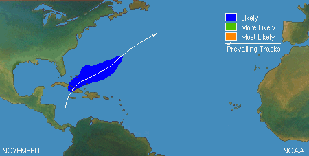
Most likely tropical cyclone tracks during November
The risk for a tropical cyclone moving through a particular 5X5 degree square of latitude and longitude during September (the peak of the season) ranges from about 25% to about 45% across the Gulf of Mexico, Southwestern North Atlantic and Caribbean Sea. This means that the risk for being near a tropical cyclone at the height of the hurricane season is less than 2% for any given day.
Cruise ships today are very hi-tech and are equipped with the latest communications and navigation systems and often also employ a professional weather routing service. If a tropical storm or hurricane is moving through or forecast to move through their area of operations, they will reroute the ship to avoid the storm or direct the vessel to a different port of call. This doesn’t mean that you will not experience some rough weather, however.
During the summer and early fall, the risk of encountering rough seas (8 feet or more) is generally low (10 percent or less). This does not mean you won’t encounter some rough weather if a cruise ship navigates around a particular storm. During the winter months, however, wind conditions tend to be higher so it can be a bit rougher. The risk for rough seas (8ft or higher) increases in winter up to 40 percent. Fortunately, modern cruise ships use stabilizers to minimize the rocking and rolling motion of the vessel greatly diminishing the chances of passengers being adversely affected.