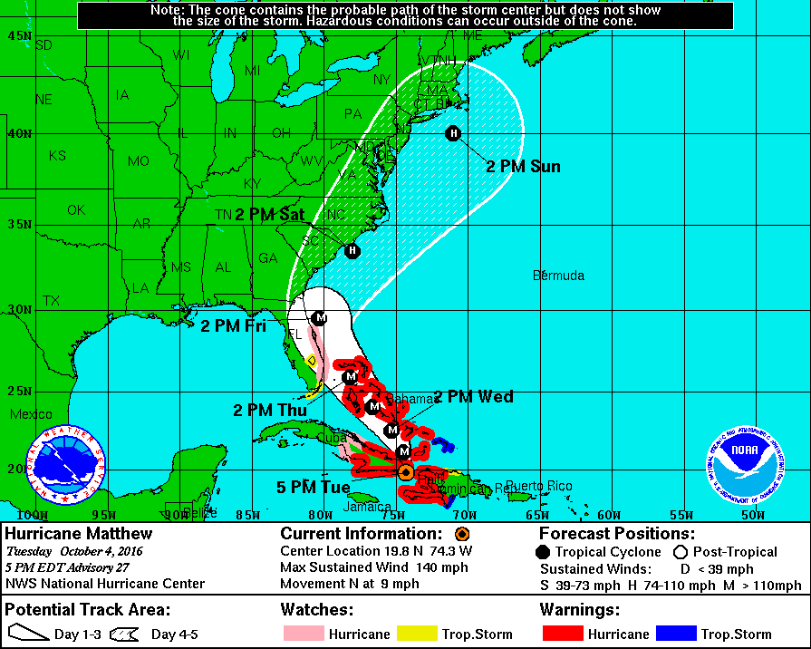
Possible Tracks for the 1848 Tampa Hurricane. image courtesy of James B. Elsner, Department of Geography Florida State University
It has been quite a while since a major hurricane has made a direct landfall in the Tampa Bay area but back before the Civil War two hurricanes hit the Tampa Bay area within about 2 weeks of each other.
In 1848 Tampa was a small village of fewer than 200 people, outside of the military garrison located at Fort Brooke (now down town Tampa). Earlier that year, the county of Hillsborough had appointed Louis Covacevich and Samuel Bishop as the first pilots of the port of Tampa. In May, the lighthouse at Egmont Key started operations and just two weeks before the first hurricane hit, Tampa’s first school opened on September 11th. (1)

Fort Brooke (Image Credit – The Tampa Bay History Center)
The first of the two storms was probably the most intense hurricane ever to affect Tampa and occurred on Monday, Sept. 25th. It came to be known as “The Great Gale of 48” and was described by survivor, William Henry Whitaker, as “the granddaddy of all hurricanes.” (7)
The September 1848 storm was an intense hurricane with estimated maximum winds of between 101-135 mph at landfall. (2)(5). The storm moved north-northwestward off the west coast of Florida causing damage at Charlotte Harbor before it turned toward the northeast and then east-northeast making landfall near Clearwater during the early afternoon of Sept. 25th with an estimated minimum pressure of about 945mb.(4)
Storm Accounts
The evening before, the winds began to gust from the northeast with occasional showers. It was reported by residents that the bay “glowed with phosphorescence almost bright enough to read by”. By 9am Monday morning the increasing southeasterly winds began to veer southerly and later southwesterly as the tide rose rapidly and the “wind blew with unprecedented violence”. The violent winds continued through the afternoon only subsiding sometime between 6 and 8 PM that evening. The maximum winds in Tampa (Ft. Brooke) occurred between 1 PM and about 4 PM on the 25th as the wind veered southerly to southwesterly. (1).
The barometer at Ft. Brooke fell from 1013mb at 9 PM on the 24th to a minimum of 954mb during the peak of the storm on the afternoon of the 25th.(3) A letter form Maj. R.D. S. Wade at Ft. Brooke stated that “all the wharves and most public buildings at the fort were destroyed and that flooding was exceptionally great but no lives were lost”. The post surgeon reported that the tide rose to 15 ft. above low water and that the “water rose very fast between 1000 and 1400”. It was also reported that all of the vessels in the port were driven up the river and destroyed by the high winds and storm surge. (2) Other accounts stated that great waves covered most of the islands within the bay and that the garrison at Fort Brooke was almost completely inundated by water and waves pounded and destroyed the barracks, horse shed and other structures and only the tops of the trees could be seen. The recently opened lighthouse at Edmont Key was badly damaged and had to be rebuilt.

Fort Brooke was one of the largest military establishments in the United States when this map was made in January, 1838. Image Credit Tampa Bay History Center
After passing Tampa the hurricane moved east-northeast across Florida passing off the Florida East Coast just north of Cape Canaveral. Many of the navigation routes were reported filled with sand and closed to traffic making any charts created prior to 1848 useless. (2)
Every building on the bay and river was destroyed except for the Palmer Hotel which was badly damaged. At the Garrison the church on the beach, the soldier’s barracks, the Indian agent’s office and the Ferris residence, store and warehouse were wrecked. According to Juliet Axtell, the wife of the Army Chaplain, “there were not more than four or five buildings left standing” and she concluded in a letter that “Tampa was no more.”(1)
Just two weeks after this major hurricane nearly destroyed Tampa, a second hurricane visited the Florida West Coast on October 11-12th. A ship 20 miles southeast of Cape St. George reported northeast hurricane force winds causing its lee rail under water for eight hours. In Tampa this storm was not as intense as the earlier one; however, it did cause a storm surge to about 10 ft in Tampa Bay.(2)
An interesting legend regarding the 1848 Hurricane is that it created a new pass through a barrier island which was discovered by a reformed pirate named John Levique. Today the pass is known as John’s Pass.
References:
- Brown, Cantor. Tampa Before the Civil War; The Tampa Bay History Center, 1999
- Barnes, Jay. Florida’s Hurricane History, The University of North Carolina Press, 1998
- Ludlum, David M. Early American Hurricanes 1492-1870, American Meteorological Society.
- Ho, F. P. (1989), Extreme Hurricanes in the Nineteenth Century, NOAA Tech. Memo. NWS HYDRO-43, 134 pp., National Oceanic & Atmospheric Administration, Washington, D.C.
- Dunn, G. E., and B. I. Miller, 1964: Atlantic Hurricanes, Louisiana State University
- Bossak & Elsner Plotting Early Nineteenth-Century Hurricane Information
- Grismer, Karl, The Story of Sarasota.The Florida Grower Press. Tampa, 1946