Super Typhoon Meranti Tuesday update

Satellite Image

Satellite Image

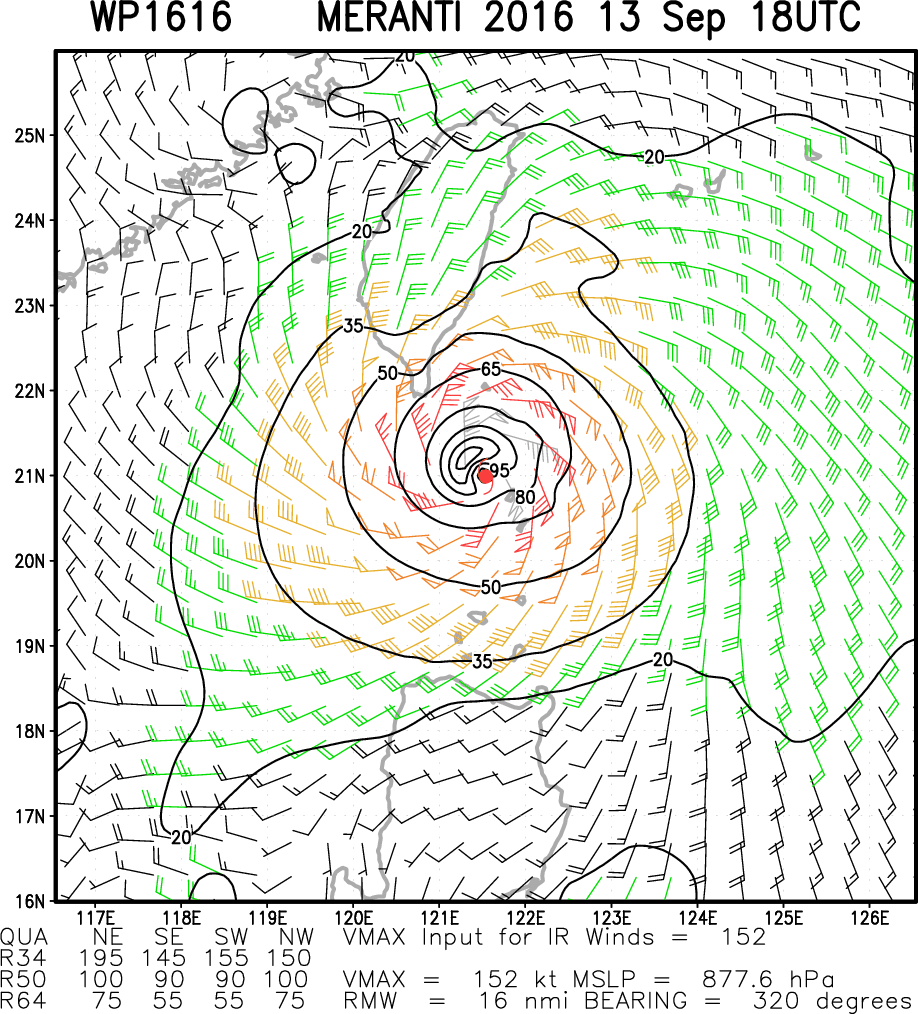
Sept 13th 1800UTC:  Max wind 165 knots with gusts to 200 knots.  Radius of hurricane force winds 50 NM southwest and 70 NM northeast.  Radius 50kt or higher winds: 90NM southwest to 120 NM northeast.

Movement 290 degrees at 9 knots.  Max significant wave height: 48 feet (14.6 meters).

The center is passing over the Luzon Straits and then moves out over the South China Sea making landfall on the coast of China about 1200UTC on the 15th with max winds of 110-120 knots.

Wind Field Analysis

Wind Field Analysis

JTWC Forecast track

JTWC Forecast track

Posted in Ocean Storms, Tropical Cyclones | Tagged , , , , , , | Leave a comment

Super Typhoon Meranti Monday Update


NOAA IR Satellite Image

NOAA IR Satellite Image

Super Typhoon Meranti has deepened rapidly over the past 24 hours and now has peak winds of 155 knots with gusts to 190 knots as it moves WNW at about 12 knots.

The radius of hurricane force winds extend 45 NM to the south and 60-100 NM to the north.  50 knot or higher winds extend outward 60NM to the southwest and 115NM to the northeast. Maximum significant wave heights are estimated to be about 47 feet (14.3 meters).

Estimated Wind Field Super Typhoon Meranti Max wind 155 knots.

Estimated Wind Field Super Typhoon Meranti Max wind 155 knots.


Meranti is forecast to maintain this intensity for another 12-18 hours before slowing weakening.  Max winds will still likely be 130-140 knots as it nears the southern tip of Taiwan during the 14th between 00-06 UTC.  The current track takes the center over the southern tip of Taiwan but some models show it passing just southward of Taiwan over the Luzon Strait.

JTWC Forecast Track

JTWC Forecast Track

Posted in Ocean Storms, Tropical Cyclones | Tagged , , , , , , | Leave a comment

TS Meranti Saturday update

TS Meranti IR Satellite Photo

TS Meranti IR Satellite Photo

TD 16 has deepened rapidly over the western North Pacific with max winds now at 45 knots and forecasts suggest that Meranti will reach typhoon strength in 24 hours.  Meranti could make landfall on Taiwan about 0600UTC on the 14th with max winds of 110-120 knots.    At landfall hurricane force winds will likely extend outward about 40-50NM.

JTWC Forecast Track

JTWC Forecast Track

Posted in Ocean Storms, Tropical Cyclones | Tagged , , , , | Leave a comment

Significant Typhoon likely over Western North Pacific

IR Satellite Photo

IR Satellite Photo

TD16 over the western North Pacific, located about 175 NM WNW of Guam has been moving towards the WNW and is forecast to become a tropical storm within 12 hours and a typhoon in 36-48 hours.  This storm could reach max winds over 100 knots 3-4 days.westpac1

Posted in Ocean Storms, Tropical Cyclones | Tagged , , , | Leave a comment

Hermine Monday Update

NOAA NHC Track Forecast

NOAA NHC Track Forecast

Hermine remains a post-tropical cyclone with max winds estimated at 60 knots and continues to drift slowly towards the north or northeast, however blocking high pressure to the north should steer Hermine more towards the northwest during the next 24-36 hours before again turning  northeast. A gradual weakening is also expected to develop after 24 hours.  There are 2 models that still bring Hermine back west including the NAM model while most keep it offshore while a couple bring it over or close to Cape Cod or Nantucket Island.

Forecast model tracks

Forecast model tracks

Hermine Wind Field via http://rammb.cira.colostate.edu/

Hermine Wind Field via http://rammb.cira.colostate.edu/

Posted in Ocean Storms, Tropical Cyclones | Tagged , , , , | Leave a comment

Hermine Sunday Update

NOAA NHC Track Forecast

NOAA NHC Track Forecast

Hermine remains a deep cyclone off the US East Coast and an Air Force reconnaissance aircraft measured peak surface winds near 60 kt.  The circulation is over warm water so Hermine could regain some tropical characteristics during the next 2-3 days.

Currently the center continues to move towards the northeast away from the Middle Atlantic coast, however, a turn towards the north or NNW is expected during the next 36-48 hours before returning to a NE or ENE track. Forecasts suggest Hermine will reach hurricane strength by late Monday but will weaken again by the 7th.   Currently significant wave heights are up to 27 feet (8.2 meters) to the northwest of the center.

Model Storm tracks via tropicaltidbits.com

Model Storm tracks via tropicaltidbits.com


The risk for encountering gale force winds are currently estimated to be:

Philadelphia – 25%
Atlantic City – 35%
New York City – 36%
Montauk Point – 62%
Boston – 48%

ASCAT Satellite Surface Winds

ASCAT Satellite Surface Winds

NOAA OPC Wave chart

NOAA OPC Wave chart

Posted in Ocean Storms, Tropical Cyclones | Tagged , , , , , , | Leave a comment

Hermine Saturday Update

NHC Forecast Track

NHC Forecast Track

Hermine is now transitioning into a post-tropical storm and currently has max winds of about 55 knots.  Over the next 2-3 days Hermine will re-intensify over warm ocean water and is forecast to regain hurricane strength by early Sunday as it drifts or meanders off the coast.

The slow motion and large wind field will result in a long duration of hazardous conditions along much of the mid-Atlantic coast extending into southern New England through the holiday weekend. hermine3


The various models still show a high degree of uncertainty, however, most now keep the center offshore.

Current wind field via http://rammb.cira.colostate.edu/

Current wind field via http://rammb.cira.colostate.edu/

Posted in Uncategorized | Leave a comment

TS Hermine

TS Hermine is forecast to move off the coast of NC early Saturday and move slowly over some very warm ocean waters allowing the storm in intensify back to hurricane strength off the coast of Delaware by Monday afternoon or evening.

NHC Official Forecast Track

NHC Official Forecast Track


Thereafter Hermine will transition into an extra-tropical low and start to move off towards the northeast.  The various models show a large amount of uncertainty in track and intensity forecasts which could have a significant effect on the forecasts for cities from DC to Boston.

TS Hermine model forecast tracks : source tropicaltidbits.com

TS Hermine model forecast tracks : source tropicaltidbits.com


Currently the risk of encountering tropical storm force winds are:

DC: 35-40%
Phly: 55-60%
NYC: near 60%
Boston: 35-40%

NHC Probability of encountering tropical storm force winds

NHC Probability of encountering tropical storm force winds

Posted in Ocean Storms, Tropical Cyclones | Tagged , , , , | Leave a comment

Earl Now a Hurricane

NOAA NHC has upgraded Earl to a hurricane. A NOAA Hurricane Hunter aircraft just reached Earl and measured maximum sustained winds of 75 mph (65 knots) – a Category 1 hurricane on the Saffir-Simpson Hurricane Wind Scale. Earl is centered as of 4 p.m. CDT about 70 miles (110 km) northeast of Isla Roatan, Honduras, and about 150 miles (240 km) east of Belize City, Belize. On the forecast track, the core of Earl will continue to pass near the Honduras Bay Islands during the next few hours, and then make landfall in Belize tonight or early Thursday.  

Posted in Ocean Storms, Tropical Cyclones | Tagged , , , | Leave a comment

TS Earl Nears Coast of Belize

TS Earl Satellite Photo

TS Earl Satellite Photo

TS Earl as of 1500UTC was nearing hurricane force with a central pressure of 991 mb and max winds estimated at 60 knots. Earl is moving westward at about 12 knots. Conditions favor some additional strengthening and Earl could reach hurricane intensity prior to landfall in Belize late tonight. Currently damaging 50 knot or greater winds extend out only 20-30 NM north of the center.

NOAA NHC Forcast Track

NOAA NHC Forcast Track

Posted in Ocean Storms, Tropical Cyclones | Tagged , , , | Leave a comment