
NOAA Visible Satellite image Hurricane Nate
Hurricane Nate continues to intensify over the warm Gulf of Mexico as it moves rapidly toward the north-northwest at 23 knots (26 mph). Currently max winds are 80 knots (90 mph)but conditions appear favorable for Nate to continue strengthening for the next 12 hours prior to landfall.
Presently, hurricane force winds extend outward only about 30 NM on the east side of Nate with 50 knot (58 mph) or higher winds extending outward 50-60 NM but only on the east side of the storm. Maximum significant wave height is 28 feet (8.5 meters).

NOAA NHC Forecast Track Hurricane Nate
Nate is expected to bring life-threatening storm surge flooding near and well east of where the center makes landfall, and a storm surge warning is in effect from Morgan City, Louisiana, to the Okaloosa/Walton county line in Florida. Maximum flooding of 7 to 11 feet above ground level is expected in portions of southeastern Louisiana and along the Mississippi coast. Residents in these areas
should immediately heed any evacuation instructions given by local
officials.
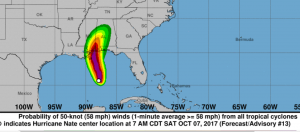
NOAA NHC forecast risk for 50 knot (58 mph) or higher winds
Nate is forecast to reach Category 2 intensity before landfall.
A hurricane warning is in effect for portions of the northern Gulf
Coast from Louisiana to Alabama, with the strongest winds expected
to occur primarily to the east of the center. Preparations to
protect life and property should be rushed to completion in these
areas, as tropical storm conditions will first arrive in the warning
area this afternoon.
Nate’s fast forward speed after landfall will bring tropical-
storm-force winds well inland across portions of the southeastern
U.S. Tropical storm watches and warnings are in effect for portions
of southeastern Mississippi, Alabama, and western Georgia.
Nate will bring heavy rainfall of 3 to 6 inches with isolated
totals of 10 inches east of the Mississippi River from the central
Gulf Coast into the Deep South, eastern Tennessee Valley, and
southern Appalachians through Monday, resulting in the potential for
flash flooding in these areas.
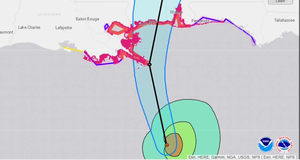
NOAA close up track forecast
Radar Loop:


