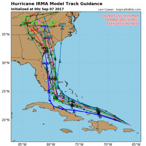
 Major Hurricane Irma at 0300UTC Sept 7th (11PM EDT Sept. 6th) was centered near 19.4N 66.8W and was moving towards the west-northwest at 14 knots (16mph) with a minimum central pressure of 916 MB and max sustained winds of 160 knots (185 mph) with gusts possible to 195 knots (225 mph).
The radius of hurricane force (64kt or higher winds) currently extends out 45NM except 30 NM to the southwest. The radius of storm force (50 knot) winds extends outward 100 NM to the northeast and 50 NM to the southwest. Gale force (34kt or higher) winds extend outward 160 NM to the northeast and 80 NM to the southwest. Maximum significant wave heights estimated to be 53 feet (16 meters).
Comments:
As Irma moves towards the WNW the circulation will start to interact with the larger islands of Hispaniola and Cuba which should tend to weaken the max winds over time, however the center is moving over warmer sea temperatures which will tend to try to counter that. Irma is expected to maintain a west-northwest track for 48-72 hours, and then start to turn more towards the northwest to north due to an upper-level trough moving into the southeastern US.
Model runs this afternoon and this evening continue to show tracks mostly up along the east coast of Florida or just offshore then heading northward, eventually towards the Georgia and South Carolina coasts.
Florida Impact: Current model trends suggest somewhat reduced risk for the Florida West Coast but continued risk for the Florida east coast. The highest risk for encountering hurricane force winds along the coast of Florida is currently between Marathon northward to West Palm Beach. If the center remains east of the Florida coast then the impact to the Florida East Coast might be diminished, however, position forecast out 3-4 days have an average error of 100-175 miles so even the Florida West Coast is not yet out of the woods on this one.
Click here for the latest NOAA NHC Advisory

