Cat 5 Hurricane Maria bears done on Puerto Rico

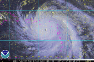
NOAA Satellite image of Hurricane Maria

NOAA Satellite image of Hurricane Maria

Hurricane Maria at 5 PM EDT (2100 UTC) has continued to strengthen with max winds now at 145 knots (165 mph) and with a central pressure of 916 mb.  Maria was moving towards the west-northwest (300 degrees) at 9 knots over the eastern Caribbean Sea.

Hurricane force winds currently extend outward about 30 NM while 50 knot (58mph) or higher winds extend outward 80 NM to the north and about 60 NM to the south.  Max significant wave height 41 feet (12.5 meters).Maria track
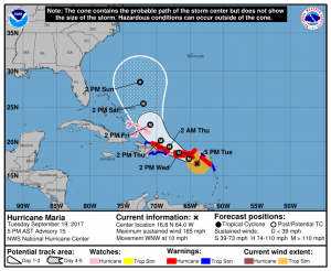
The eye of Maria is forecast to move near the U. S. Virgin Islands tonight and across Puerto Rico on Wednesday, followed by a track just north of the eastern Dominican Republic Wednesday night and Thursday, then turning towards the northwest then north Friday and Saturday.

Maria’s core is expected to move near or over St. Croix and Puerto Rico tonight and Wednesday, bringing life-threatening wind, storm surge, and rainfall impacts to portions of those islands.

A gradual weakening trend is forecast after the eye passes over Puerto Rico.

Risk for encountering sustained winds of hurricane force.

Risk for encountering sustained winds of hurricane force.

Latest NOAA NHC Advisories on Maria can be found here

About Fred Pickhardt

I am a marine meteorologist and sailed briefly with American Export Lines in the Far East trade after graduating from State University of New York Maritime College. I have extensive experience in weather analysis, weather forecasting, optimum ship routing, vessel performance evaluations and forensic weather event reconstructions. I founded Ocean Weather Services and as Owner and Chief Consultant currently provide optimum ship routing services and forensic marine weather reports to the maritime industry.
This entry was posted in Ocean Storms, Tropical Cyclones and tagged , , , , , , . Bookmark the permalink.

Leave a Reply

Your email address will not be published. Required fields are marked *