La Niña and the Azores-Bermuda Ridge: Impact on the 2024 Hurricane Season

Catagory 5 Hurricane Dorian

Introduction

During the 2023 hurricane season, a strong El Niño event had significant effects on the Azores-Bermuda Ridge, leading to a weakening of this high-pressure system. As a result, surface winds, especially in the tropical Atlantic, decreased. This reduction in surface winds had several consequences, including unusual sea surface warming due to decreased ocean mixing and evaporation. Additionally, other factors, such as a strong  Atlantic Multi-decadal Oscillation (AMO), reduced sulfate particles from cleaner shipping fuels, the Hunga-Tonga volcanic eruption, and lower levels of African dust, may have contributed to the overall climate conditions.

June 2023 Surface Pressure Anomaly


In this analysis, I will explore the transition from El Niño to La Niña and its potential impact on the 2024 hurricane season.

La Niña and Wind Shear

El Niño to La Niña Transition

Currently, El Niño is weakening rapidly, and meteorologists anticipate the development of a La Niña event by the main 2024 hurricane season. La Niña is characterized by cooler-than-average sea surface temperatures in the central and eastern tropical Pacific Ocean. Just how will this transition affect the Atlantic hurricane environment?

Wind Shear and Tropical Cyclones

During La Niña events, wind shear in the tropical Atlantic typically decreases. Wind shear refers to the change in wind speed and direction with altitude. Reduced wind shear creates favorable conditions for the development and intensification of tropical cyclones. With weaker wind shear, disturbances in the tropics can organize more effectively, potentially leading to stronger storms.

The Strengthened Azores-Bermuda Ridge

Trade Winds and Storm Paths

La Niña tends to strengthen the Azores-Bermuda Ridge, a high-pressure system located in the North Atlantic. As this ridge strengthens, trade winds increase. These trade winds play a crucial role in steering tropical cyclones. Here’s how:

  1. Westward Movement: A stronger Azores-Bermuda Ridge tends to steer Atlantic tropical cyclones farther west. This westward shift increases the risk of landfalls in regions such as the Caribbean, the US East Coast, and the Gulf Coast.
  2. Trade Wind Enhancement: Stronger trade winds enhance ocean surface mixing. This process involves cooler water from deeper ocean layers rising to the surface. Consequently, the sea surface temperatures may gradually cool during the hurricane season.
  3. Evaporation and Moisture Transport: The intensified winds also lead to increased evaporation and moisture transport. This contributes to further cooling of the sea surface.

Azores-Bermuda Ridge controls Tropical Cyclone Tracks

Sea Surface Temperature Anomalies

Outlook for 2024

Given the current very high sea surface temperature anomaly in the tropical North Atlantic, it is likely to remain above normal as we move into the peak of the 2024 hurricane season. However, the strengthening La Niña and the associated changes in wind patterns may gradually mitigate this anomaly.

Tropical North Atlantic Sea Surface Temperatre Anomaly

In summary, the transition from El Niño to La Niña could significantly influence the behavior of tropical cyclones in the Atlantic. If the Azores-Bermuda Ridge strengthens during this hurricane season we can expect an increased risk of tropical cyclone landfalls in regions such as the Caribbean, the US East Coast, and the Gulf Coast. As wind shear decreases, tropical cyclone frequency and intensity can increase so it will be essential to stay informed about the evolving conditions and their potential impact on hurricane activity.

Ocean Weather Service


Posted in Uncategorized | Tagged , , , , , , , | 1 Comment

Gulf Low to produce Heavy Rains and Strong Winds

NOAA Surface Forecast for Saturday morning

A low is forecast to form over the south-central Gulf of Mexico Friday night into early Saturday morning, deepening and moving northeast across northern Florida Saturday night, reaching the coast of Georgia by early Sunday before turning northeast to north across the Mid Atlantic States Monday.


NOAA Surface Forecast Monday Morning

A heavy rain event with possible flash flooding is expected across Florida Saturday afternoon and Saturday night with gale force winds developing over the northeastern Gulf of Mexico beginning late Friday night with gale to storm force winds building seas 5-10 meters (16-33 feet) likely over the ocean off the Southeast US East Coast Saturday night and Sunday then spreading northward.

NOAA Precipitation Forecast


Ocean Weather Service

Posted in Uncategorized | Tagged , , , | Leave a comment

Heavy Rains and Gale Winds along Florida Coast

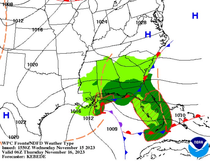
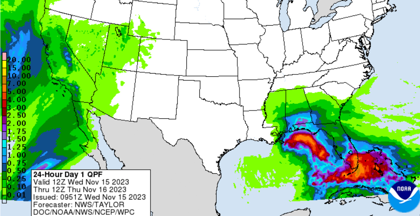
A gale low over the northeastern Gulf of Mexico will move slowly east bringing beneficial rains to drought-stricken areas of the central and eastern Gulf Coast. A secondary low center will form along the Florida East Coast early Thursday and will produce some heavy rainfall in southeast Florida from West Palm Beach and Fort Lauderdale down through Miami and Homestead. In addition, strong to gale force winds are likely with seas building 3-5 meters (10-16 Feet) north of the developing secondary low center Thursday.

NOAA WPC Surface Forecast Wednesday Night

Extremely heavy rainfall rates are possible which may approach or exceed 2 to 3 inches per hour and may produce rainfall totals upwards of 3 to 6 inches with some isolated max amounts approaching 10 inches.

NOAA NWS 24 Hour Rainfall Forecast

NOAA NHC Wave Forecast Thursday Evening

Ocean Weather Services


Posted in Uncategorized | Tagged , , | Leave a comment

A Second Hurricane-Force Storm heads for English Channel Approaches

NOAA OPC Surface Analysis

A 2nd rapidly deepening storm low east of Newfoundland will move east then east-southeast with winds to 65 kts building significant wave heights to 14 meters (46 feet) during the next 36 hours over the eastern North Atlantic north of the Azores.  Thereafter the low will begin to weaken and move across southern England into the North Sea.

NOAA OPC Surface Forecast 1200Z 04 November

Again ship delays are likely for both inbound and outbound English Channel traffic as well as north and southbound traffic in the Bay of Biscay.


NOAA OPC Wave Height Forecast 1200Z 04 November

Ocean Weather Services

Posted in Uncategorized | Tagged , , , , | Leave a comment

Two Hurricane-Force North Atlantic Storms

Meteosat Image North Atlantic

A hurricane-force storm low over the eastern North Atlantic will move rapidly across southern England and into the North sea with winds to 70 kts and significant wave heights to 12 meters (about 40 feet) in the English Channel Approaches and portions of the Bay of Biscay during the next 18-24 hours.


NOAA OPC Surface Analysis 1200 UTC 01 Nov 2023


A second low developing SSE of New England will move NE then E and deepen rapidly into another hurricane-force storm low over the Central North Atlantic with wind to 70 kts and significant wave heights building 12-14 meters 40-46 feet) over the next 48-72 hours, approaching the English Channel Approaches by the 4th. 

NOAA OPC Surface Forecast 0000Z 03 Nov. 2023

NOAA OPC Wave Height Forecast

Both storm systems will negatively impact both east and west bound shipping lanes for next few days.


Ocean Weather Services

Posted in Uncategorized | Tagged , , , , | Leave a comment

Intense Storm Heads for English Channel Approaches

NOAA OPC Surface Analysis 1200 UTC 31 October

A gale low over the western North Atlantic will move ENE at 45 kts, deepening rapidly into a hurricane-force 953 mb storm low over the English Channel Approaches by 0000 UTC November 2nd with winds to 70 kts and significant wave heights to 12 meters (about 40 ft) south of England and Ireland and portions of the Bay of Biscay. Thereafter the storm center will move across southern England and into the Northsea.

NOAA OPC Surface Forecast 0000 UTC 2 November


Significant shipping delays are possible for both inbound and outbound English Channel traffic.


Ocean Weather Services

Posted in Uncategorized | Tagged , , , , , | Leave a comment

Hurricane-Force Storm to affect Bay of Biscay and English Channel Approaches

NOAA OPC Surface Forecast 1200 UTC 31 October

A low pressure disturbance will move off the New England coast early Monday, moving rapidly ENE deepening to a gale low south of Newfoundland then deepening rapidly into a hurricane force storm reaching the English Channel Approaches by 0000 UTC November 2nd with winds of 65-75 kts and significant wave heights building to 12-14 meters (40-46 feet) over the Bay of Biscay and Channel approaches.  This will likely cause issues, particularly with westbound shipping. 

ECMWF Wind Forecast for 0000 UTC 2nd November via windy.com

Ocean Weather Services

Posted in Uncategorized | Tagged , , , , , | Leave a comment

Tammy now a Post-Tropical Hurricane-Force Storm

NOAA Satellite Image Tammy

Hurricane Tammy has transitioned to a pot-tropical hurricane-force storm low with min pressure of 973 mb and max winds to 75 kts and significant wave heights to 10 meters (33 ft) as it moves NNW at 10 kts. 

NOAA OPC Wave Height Analysis

X-Tammy is forecast to gradually weaken as it moves NW to WNW during the next 48 hours, thereafter turning back eastward.

NOAA OPC 48 hr Surface Forecast


Ocean Weather Services

Posted in Uncategorized | Tagged , , | Leave a comment

Catastrophic Cat 5 Otis makes landfall near Acapulco

Cat 5 Hurricane Otis making lanfall near Acapulco, Mexico

Major Hurricane Otis continued to strengthen until near the time of landfall in southern Mexico near Acapulco, reaching a catastrophic Category 5 with max wind of 145 kts (165 mph). 


Otis intensified very rapidly from a tropical storm to a Cat 5 hurricane in about 18 hours as it moved over sea surface temperatures from 28 C to about 30 C as it approached the coast.  Although the SSTs are warm, they are not all that unusual for the area. The very rapid intensification will be a subject for further study.  In 2015  Hurricane Patricia grew from a tropical storm to a Category 5 hurricane in just 24 hours with max winds of 185 knots (215 mph) but weakened to 130 kts (150 mph) at landfall. 

Otis has moved onshore in the greater Acapulco area and now that the center is moving inland, rapid weakening is expected.


Hurricane Otis Damage in Acapulco, Mexico

Ocean Weather Services


Posted in Hurricane, North Pacific, Ocean Storms, Ocean Weather, Tropical Cyclones | Tagged , , , , | Leave a comment

Hurricane Otis nearing Cat 5 Strength

NOAA IR Satellite Image Hurricane Otis

Hurricane Otis is undergoing very rapid development with max winds currently at 125 kts with a min pressure of 941 mb and significant wave heights estimated 12-13 meters (40-43 feet) as it moves NNW at 7 kts. Otis is a small but powerful storm with hurricane force winds extending outward 20-25 nm and 50 knot winds outward 30-40 nm   Otis is forecast to peak near 140 kts (Cat 5) tonight, prior to landfall.  

NHC Forecast Track for Hurricane Otis


Otis is forecast to be a catastrophic Category 5 hurricane when it reaches the southern coast of Mexico late tonight or early Wednesday. Heavy rains from Otis will continue to impact areas of southwest Mexico this week.  This rainfall will produce flash and urban flooding, along with mudslides in areas of higher terrain.

A Hurricane Warning is in effect for…  Punta Maldonado westward to Zihuatanejo

A Hurricane Watch is in effect for…  Lagunas de Chacahua to Punta Maldonado


Latest NHC Advisory

Ocean Weather Services

Posted in Hurricane, North Pacific, Ocean Storms, Ocean Weather, Tropical Cyclones | Tagged , , , , | Leave a comment